The big story for next week will be a shot of cold air that is forecast to surge rapidly Southward by midweek, giving some areas their first frost and/or freeze of the season, possibly as far South as northwest Arkansas.


Cold Air to Bring Fall-Like Chill to Much of the Central and Eastern U.S.
The image below shows the GFS model forecast valid 1am CDT Tuesday morning, October 18th. I have drawn the location of the cold front in blue:


Now that you've seen the highlights, lets take a look at the ingredients in greater detail...
The image below shows the GFS model forecast valid 1am CDT Tuesday morning, October 18th. I have drawn the location of the cold front in blue:

Several hours later, by 4pm CDT that same day, the front is forecast to have surged Southward all the way into the Gulf of Mexico:

The strongest and most widespread chill is forecast to settle into the region behind the front early on Thursday morning, October 20th. The image below is the GFS model again, valid at 7am CDT on Thursday the 20th:

Note the thin blue line encircling much of the Northern Plains and upper Mississippi Valley, extending on South as far as east-central Kansas and an isolated patch of northwest Arkansas. That's where the model is forecasting a temperature of 32 degrees or lower at that time.
Temperatures are forecast to average some 10-15 degrees below normal across a large portion of the central and southern Plains on Thursday morning, October 20th:

The chill will spread into the lower Mississippi and Tennessee Valley areas by Friday and Saturday mornings, as shown by the "departure from normal" temperature images below:


The GFS model's forecast of low temperatures valid at 7am CDT each morning for Tuesday, Wednesday, Thursday and Friday of next week are shown below:


Rainfall Spotty Along Front - Except in Florida/New England:
Unfortunately, at this time, it doesn't appear as though precipitation will be widespread with the passage of this front in the drought stricken southern Plains. The GFS model forecast of total precipitation for the period today through next Saturday, October 22nd, is shown below:

The human interpretation of all of the model data is shown on the latest HPC rainfall forecast valid today through Thursday, October 20th, as shown below:

As you can see, some decent 1 to 1.5 inch rains are forecast along the front from Missouri into the Ohio Valley (this would be early in the week), with the main show in interior New York and down in Florida. It appears that some or all of the tropical energy currently building near the Yucatan region will be pulled up along and ahead of the cold frontal boundary by mid to late week, bringing widespread, heavy rain to the "Sunshine" state. Localized amounts of 6+ inches are forecast in this region, mainly during the Wednesday-Thursday timeframe.
High Fire Danger Behind Front in Drought Region:
The lack of moisture ahead of the cold front across the southern Plains, along with strong and gusty North-Northwest winds will bring very high fire danger to the region both Tuesday afternoon and possibly again Wednesday.

Tropical Outlook - Widespread Rain for Texas in 2 Weeks?
In the Tropics, an area of disturbed weather continues to spin about near the Yucatan peninsula. This system is forecast by most models to become absorbed into the cold front that is expected to surge into the Gulf early next week, spreading very heavy rains Northeastward into Florida and Cuba by Wednesday and Thursday, October 19th and 20th.
The GFS model continues to hint that at least of piece of the original energy, or perhaps a brand new circulation, will persist near the Yucatan peninsula by next weekend. The forecast image valid 1pm CDT Sunday, October 23rd, is shown below, with the energy in question circled in yellow:

This area will continue to need to be watched, as the models have been very persistent in forecasting the possibility for tropical weather for nearly a week now (as first pointed out in a post on Tuesday, October 11th).
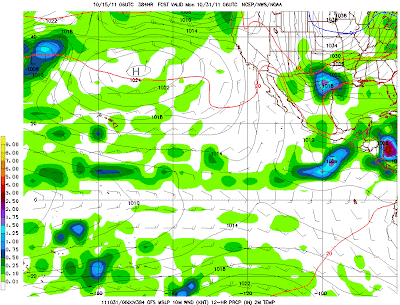
The weather pattern out over the Eastern Pacific is forecast to continue to be very active. In fact, the GFS model is hinting at another Tropical Storm or Hurricane brewing off of the Mexican coast by next weekend (very near where Hurricane Jova impacted the region earlier this week). The forecast image valid 1pm CDT on Sunday, October 23rd is shown below, with the system in question circled in yellow:

In the longer range, the model wants to bring the system onshore along the Mexican coast (after clipping the southern tip of the Baja peninsula) by 2am CDT on Wednesday, October 26th:

While that would certainly not be good news for the folks down in Mexico, I am thrilled with the model's tendency to bring moisture from the system Northeast into Texas, where it is currently forecast to merge with a cold front on or about Sunday, October 30th to early Monday, October 31st:
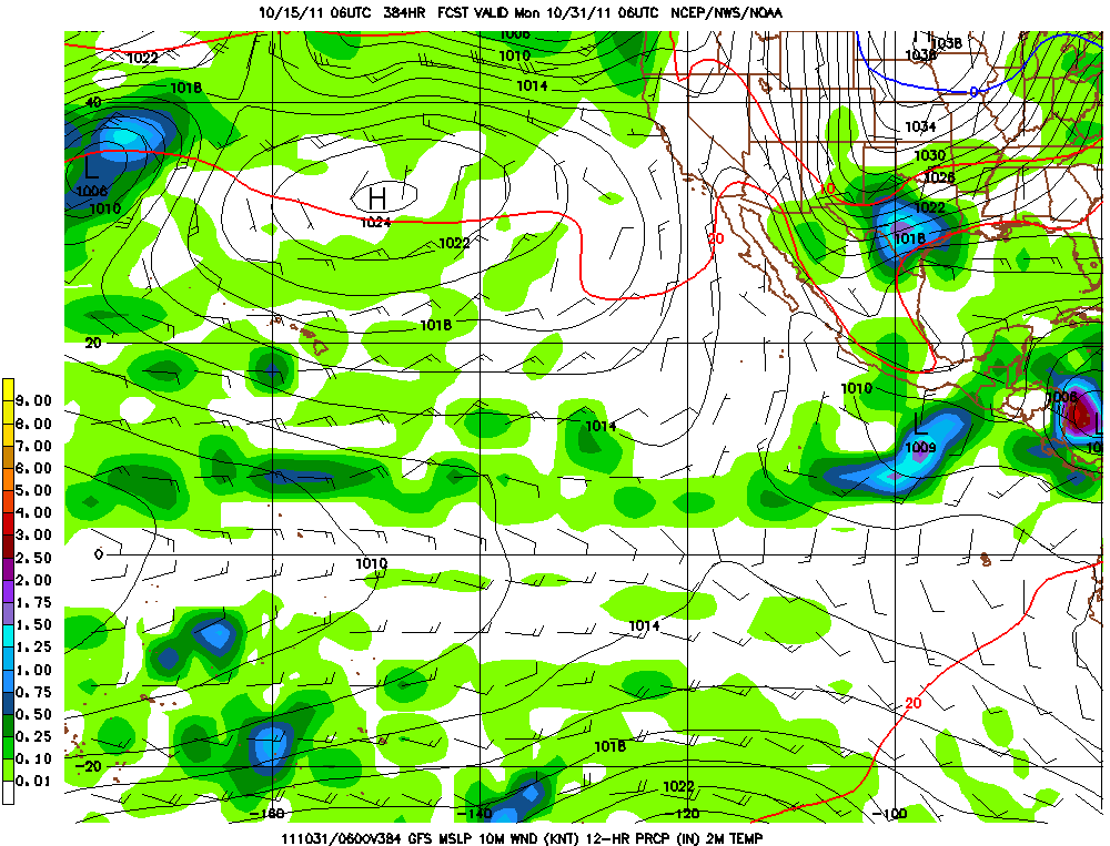
Keep in mind that we're talking about something 2 weeks out, and involving a tropical system, so there are still many things that could change, but this is certainly a promising trend to keep an eye on!
If you enjoy reading 'The Original Weather Blog', please be sure to "like" our facebook page!
1 comment:
You should do this every week. I really like it and it is very helpful for planning for bad weather. Thank you for your work to keep us educated on the weather.
-Ralph C.
Post a Comment