***Updated at 5:30 PM CST 11/17/11:
The National Weather Service has completed its survey of the Auburn area storm. They have ruled that the damage was caused by an EF-1 tornado. See excerpt of the survey report below:

-------------------------------------Orignal Post Below:
Severe storms and tornadoes struck the Deep South and Southeast U.S. in another round of fall severe weather yesterday. Unfortunately, 6 people were reportedly killed and several injured in this latest mini-outbreak.
The image below shows all severe weather reports that were received across the region, with tornado locations highlighted in the text portion on the left hand side of the image:

The cluster of reports along the east-central Alabama and west-central Georgia border (beginning near Auburn, AL) are currently classified as wind damage / possible tornado but will likely turn into one or more tornado tracks as well as some wind damage reports once storm surveys are complete later today. I have zoomed-in on this region on the image below and highlighted some of the more significant reports within the blue text boxes:


The National Weather Service has completed its survey of the Auburn area storm. They have ruled that the damage was caused by an EF-1 tornado. See excerpt of the survey report below:

I'll have more on this tomorrow...
-------------------------------------Orignal Post Below:
Severe storms and tornadoes struck the Deep South and Southeast U.S. in another round of fall severe weather yesterday. Unfortunately, 6 people were reportedly killed and several injured in this latest mini-outbreak.
The image below shows all severe weather reports that were received across the region, with tornado locations highlighted in the text portion on the left hand side of the image:

The cluster of reports along the east-central Alabama and west-central Georgia border (beginning near Auburn, AL) are currently classified as wind damage / possible tornado but will likely turn into one or more tornado tracks as well as some wind damage reports once storm surveys are complete later today. I have zoomed-in on this region on the image below and highlighted some of the more significant reports within the blue text boxes:

The damage above was caused by a rotating supercell thunderstorm that tracked from near Montgomery, East/Northeastward across the Auburn / Opelika areas. The series of radar images below show the track of the storm as it impacted the Auburn/Opelika areas. The left half of each image is the radar in reflectivity (rain, hail) mode, while the right half shows the radar in wind velocity (wind speed & direction) mode. The rotating portion of the storm in question is circled in yellow on the right half of the corresponding images:

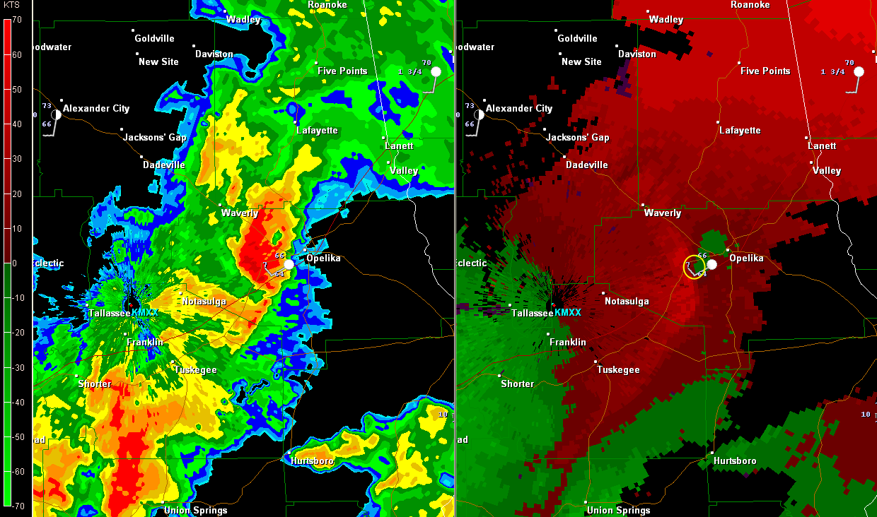


As you can see, the rotation is rather tight and well defined in the first image, and becomes more outflow wind dominated during the latter images (as indicated by the bright red returns running from North-Northwest to South-Southeast to the immediate left of the yellow circled area). It will be interesting to see how the storm surveys come out, and I'll be sure to post that information when it becomes available.
A few videos are beginning to emerge, depicting damage in and around the Auburn area (this first one starts out kind of slow but gets into more of a slide show with multiple photos toward the last quarter of the video):
This next video was reportedly shot on S. College Street in Auburn, and shows nearly horizontal sheets of rain with tree leaves and/or debris visible in the air at several points. This person should have been in shelter, but he chose to shoot this video out his front door and windows. I don't endorse that move (unless you clearly know where you are in relation to the storm's path), but it certainly makes for some interesting video at a point or two:
The next image is a close-up of the tornado reports in the Carolinas. Details (where provided) are shown on the left half of the image:

Two of the six fatalities that occurred yesterday took place in North Carolina, with 3 in South Carolina and 1 in Georgia.
I'll post updates later today and/or tomorrow as the storm surveys are complete.
If you enjoy reading 'The Original Weather Blog', please be sure to "like" our facebook page!
No comments:
Post a Comment