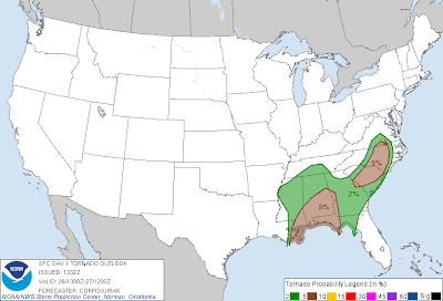
Above is the latest severe weather outlook from the SPC in Norman, OK. Severe thunderstorms are forecast within the yellow shaded areas on the image. Large hail, damaging winds and a few tornadoes are possible with the activity today.
The highest threat of damaging wind gusts will be within the areas shaded in red on the image below:
...and there are two areas with the best chance for isolated tornadoes, located within the brown shaded areas on the following image:
Thunderstorm activity has continued overnight and early this morning, and is moving Eastward along the Gulf Coast. A Tornado Watch is in effect for this activity until 12 Noon, and will likely be extended Eastward later this morning:
The threat will gradually spread into adjacent portions of Georgia this afternoon and the Carolinas by this evening. Additional and/or new development may also take place over the Carolinas tonight.
Folks living across the severe weather threat areas should remain alert today and this evening. Listen to NOAA Weather Radio or a trusted local source for the latest forecasts, updates and possible warnings. Review safety and preparedness tips in advance, and make sure that you know where to shelter if threatening weather approaches your area.
If you enjoy reading 'The Original Weather Blog', please be sure to "like" our facebook page!


No comments:
Post a Comment