As feared all week long, conditions still appear very favorable for a major episode of tornado and severe thunderstorm development across a large portion of the Plains later today and into tonight. This threat will include strong and violent, potentially long track tornadoes, as well as very large hail and damaging winds.
The latest severe weather outlook for today and tonight from the Storm Prediction Center (SPC) in Norman, OK is shown below:
Severe thunderstorms are forecast anywhere within the yellow shaded area on the image. The most pronounced threat of widespread severe weather, including damaging tornadoes, lies within the red and lavender shaded areas on the same image.
Any severe thunderstorm that forms within the red shaded and black hatched area on the image below will have a higher than normal chance of producing a tornado:
Within that overall elevated tornado risk area, any storms that form within the lavender and purple shaded areas with the black hatch marks will be particularly capable of producing strong to violent and/or long track tornadoes, which could pose a significant threat to life and property.
This pronounced threat of significant tornadoes includes the cities of Wichita, Enid, Ponca City, Oklahoma City, Tulsa, Hutchinson, Salina, Topeka, Lincoln, Grand Island, Norfolk and Omaha.
If you live anywhere within the red shaded and black hatched area on the image above, you are at a higher than normal risk of a significant tornado later today and/or tonight and should treat the situation accordingly.
Severe storms that form across the region will also be capable of producing other significant severe weather hazards, such as damaging straight line wind gusts and very large hail.
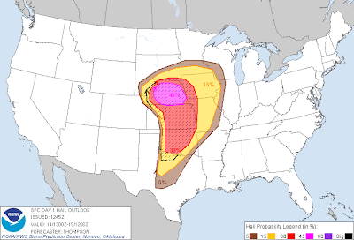
There will be a pronounced risk of damaging straight line winds within the red and lavender shaded areas on the image below:
...and a pronounced risk of very large hail (potentially 2 inches in diameter or larger) within the red and lavender shaded and black hatched areas on this image:
Initial Development Likely in Nebraska/Kansas/Northwest Oklahoma:
Severe thunderstorms are forecast to develop from central and/or western Nebraska into adjacent portions of western and central Kansas and into northwestern Oklahoma by early afternoon. These storms are likely to be discrete when they initially develop, with high potential for tornadoes, very large hail and damaging winds. A few of the tornadoes could become strong to violent and long tracked. This activity will move toward the Northeast to East/Northeast over time.
Remainder of Western Oklahoma/Northwest Texas:
It currently appears that the most likely time for thunderstorm development across the west-central and southwest Oklahoma and northwest Texas portions of the severe weather outlook area will be after 5pm. This threat will continue into the evening as storms develop and organize, with strong tornadoes, very large hail and damaging winds possible.
Significant Severe Weather Threat Into the Overnight Hours Tonight:
The threat of severe weather will continue Eastward during the overnight hours, reaching the eastern edges of the severe weather outlook areas from far eastern Nebraska and western Iowa through eastern Oklahoma by dawn on Sunday. Despite the time of day/night, conditions will remain favorable for significant severe weather during the overnight period, and it will be critical for folks in these areas to have a way to receive severe weather warnings at night.
Make Sure to Be Prepared and Stay Up to Date:
If you live across any of the threat areas described above, please pay attention to the weather today. Listen to NOAA Weather Radio, local media or another trusted source for later information and warnings. Make sure that you've re-stocked your severe weather safety kit and have identified your best sheltering option ahead of time, that way you can take quick action when the time comes.
Please check back on the blog throughout the day for updates. The next major update will be posted by mid to late morning, and we'll try to pin down specific threats and timing even more within that post.
Once storms develop and during other rapidly changing situations, be sure to also follow my facebook and/or twitter feeds for more frequent updates on specific storm threats as they happen!
If you enjoy reading the blog, please click on the icons below to "Like" my facebook page and/or follow me on twitter. You'll find posts at these locations that aren't always on the blog, especially during rapidly changing weather situations...


No comments:
Post a Comment