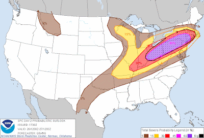
As mentioned in a post this morning, there is a threat of widespread and/or significant severe weather tomorrow across a large portion of the Ohio Valley into New England, including several heavily populated areas.
The afternoon update of the Storm Prediction Center's (SPC) outlook for tomorrow has upgraded part of the region to a "Moderate" risk of severe weather, which signifies a threat for widespread, potentially damaging storms.
The updated outlook map is shown above, with the highest risk within the red and lavender shaded areas on the image. In addition, hail greater than 2 inches in diameter and wind gusts greater than 75 mph are possible mainly within the black hatched area on the same image.
This elevated threat of severe weather includes the cities of New York City, Philadelphia, Pittsburgh, Columbus, Cleveland and Cincinnati.
The primary threat of severe weather will come during the afternoon and evening hours tomorrow, although some severe weather may occur as early as the morning hours, especially over Western and Northwestern portions of the outlook area.
Damaging straight line wind gusts and hail will be the primary threats, however a few tornadoes also cannot be ruled out. At this time, it appears that the most favorable area for potential tornado development will generally be within a swath extending from southeastern New York state and into southern New England.
Folks living across this region should prepare this evening for the possibility of severe weather tomorrow. Make sure to have a NOAA Weather Radio or other battery powered device available so that you can receive weather warnings even during a power failure. Be sure to stock up on extra batteries for the device, as well as flashlight batteries, etc., just in case.
I'd also suggest reviewing severe weather safety tips so that you can identify and prepare your best sheltering option at home or work.
For more information from the Original Weather Blog, including "live blogging" during rapidly changing weather events, please be sure to follow me on facebook and/or twitter:


No comments:
Post a Comment