As expected, bitter cold, arctic air continues to sag Southward into the lower 48 U.S. this morning. The center of the cold snap will overtake the Midwest and Ohio Valley through tonight. The cold surge will be accompanied by dangerously cold wind chill values across much of the same region.
As you can see on the current temperature map above, readings are in the teens and 20s below zero in the pink and white shaded areas, from the central and eastern Dakotas into adjacent portions of Minnesota and Wisconsin. Add in the wind, and "apparent" temperature values plummet into the 20s, 30s and even 40s below zero across much of the same region:
Wind Chill Advisories (light blue) and Wind Chill Warnings (light grey) are in effect across most of this region at the present time:
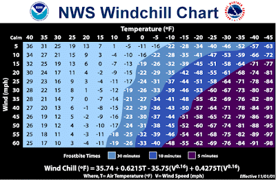
Frostbite becomes a major concern when wind chill values reach the 20s and 30s below zero, as exposed skin can freeze when subjected to such conditions for as little as 10 minutes:
While it's not likely that you'd want to be outdoors for very long in such conditions anyway, make sure that you are bundled up cover your hands and face if you must be outside for any length of time.
If you have to travel across this region, make sure your cellphone has a good charge before you leave and bring along a blanket and additional clothing layers just in case you break down. If your vehicle does break down in an area that does not have heavy traffic, its best to stay in your car, make a phone call and wait for help to arrive. You can lose track of time outdoors pretty quickly, which could lead to an increased risk of frost bite.
For more information from 'The Original Weather Blog', including shorter, more frequent posts during rapidly changing weather events, please be sure to follow me on facebook and twitter:
Coming March 2013: The Tornado Chronicles full website!
Including information on every U.S. tornado since 1950, tornado safety, preparedness and education as well as interactive radar, tornado outlooks, watches and warnings, and much more! Please show your support and follow The Tornado Chronicles on twitter and on facebook for the latest updates on tornadoes and the upcoming website!


No comments:
Post a Comment