At least 1 tornado has already been reported in Louisiana this morning. This is associated with the same storm system that affected Texas yesterday, and as feared is moving East today with a severe weather threat across the Deep South.
"Moderate damage" was reported to roofs at an industrial park near Plaquemine around 7:30 this morning in association with a storm that is currently moving toward Walker and Livingston:


"Moderate damage" was reported to roofs at an industrial park near Plaquemine around 7:30 this morning in association with a storm that is currently moving toward Walker and Livingston:

The current Tornado Warning area is indicated by the lavender polygon on the radar image, and as you can see, the rotation is associated with a "comma head" on radar (the radar signature toward the middle left portion of the tornado warning polygon), which is pretty common in this type of situation and at this time of the year.
In situations like this, we often see one or more brief tornado touch downs as long as the rotation and comma head signatures persist. While the fact that the touchdowns are generally brief is good, if they happen to take place in a populated area (as in the industrial park this morning), that's obviously not good, as damage and injury can still result.
A Tornado Watch is in effect ahead of a line of thunderstorms that currently extends from west-central Mississippi into southeast Louisiana:

The Tornado Watch area includes New Orleans and is in effect until 2pm CST:

The threat of severe weather will spread Eastward during the day, possibly as far as the Mobile area, and additional development is also forecast further North as afternoon heating makes the atmosphere more unstable. The outlook for today from the Storm Prediction Center (SPC) in Norman, OK reflects the severe weather threat in yellow and brown on the image below:

If you live across this region, please pay attention to the weather today and be ready to move to shelter quickly if threatening weather is observed or a warning is issued for your area.
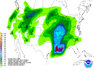
In addition to the threat of severe thunderstorms and isolated tornadoes, flash flooding will be a major problem across much of the same region. Widespread rainfall totals of 3-5 inches will be common in the purple shaded areas on the rainfall forecast map below, with 6 inches or more possible in a few locations that have repeat heavy rainfall:

For more information from 'The Original Weather Blog', including shorter, more frequent posts during rapidly changing weather events, please be sure to follow me on facebook and twitter:
If you are in need of highly customized, site specific weather forecasts and/or storm warnings for your business, school or event, be sure visit my professional webpage at WeatherGuidance.com.
No comments:
Post a Comment