
The latest National Weather Service advisories are shown above. A Blizzard Warning is in effect for the area shown in orange. A Winter Storm Warning is in effect for the area shown in pink, and a Winter Storm Watch is in effect for the area shown in blue-grey. For definitions of what each of these advisories mean, please see page 8 of the winter weather safety and preparedness guide.
Overall, not much has changed since my detailed post of yesterday evening. Below are the latest forecasts of total new snowfall from the NAM, GFS and European computer forecast models, respectively. All are valid now through 6pm CST Tuesday:


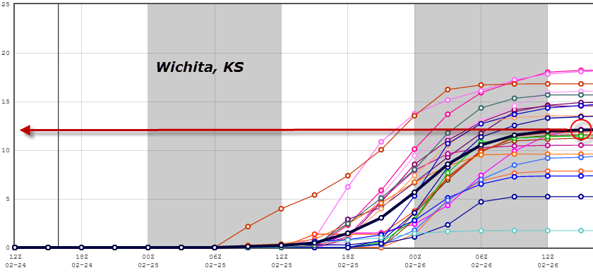
While there are some subtle differences in each, the consensus continues to favor a swath of heavy snow extending from the far northeast Texas panhandle, through northwest Oklahoma, southcentral and eastern Kansas and into northern Missouri. This generally includes the Woodward, Wichita, Emporia, Topeka and Kansas City areas.
The NAM model forecasts a maximum snowfall bullseye (near 30 inches) over northwestern Oklahoma. The GFS is forecasting the maximum snowfall to take place along the Kansas/Missouri border, just to the South of Kansas City (20-25 inches). The European is favoring a broader swath of maximum snowfall from east-central Kansas into northwestern Missouri, in or immediately South of the KC Metro area (12-18 inches), and another bullseye over northwestern Oklahoma (18-24 inches).
As I've been pointing out for several days now, a major threat with this system that we did not see in the last one will be very strong, gusty winds. These winds will cause widespread blowing and drifting snow, with white out and blizzard conditions likely in many areas. I believe much of the Winter Storm Warning area over southcentral, southeastern and east-central Kansas should be a Blizzard Warning. Hopefully we'll see the NWS make that change soon. Regardless, if you live in this region, prepare for blizzard conditions with near impossible travel conditions from late tonight through Tuesday.
I've had lots of questions about the expected Southern end of the heavier snowfall (i.e. 6 or more inches of snow). The models have been consistent for several days now in keeping the heaviest snow to the Northwest of both the OKC and Tulsa areas. There has been no change in that trend through this time.
Of those two particular metro areas, OKC is the one to keep an eye on, as any subtle change in the track of the surface low could result in locally heavier snow spreading into that area on Monday afternoon and evening. Right now, I would expect 2-4 inches in most of OKC, with widespread blowing and drifting in strong, gusty winds. Heavier amounts are likely just Northwest of there. That forecast falls in line with the latest short range model composite, which is calling for just short of 4 inches at the OKC Will Rogers Airport:

For the Tulsa area, the same model composite calls for an average of 1-2 inches of snow before precipitation ends Monday night or Tuesday morning:

The track of the surface low pressure center would have to shift dramatically to the South in order for Tulsa to receive heavier snowfall, the prospect of which does not seem likely at this time.
...and 12-15 inches at Kansas City:

For more information from 'The Original Weather Blog', including shorter, more frequent posts during rapidly changing weather events, please be sure to follow me on facebook and twitter:


Coming March 2013: The Tornado Chronicles full website!
• Interactive tornado database back to 1950 (earlier years coming soon)
• Interactive radar with live warnings and street-level zoom
• Tornado safety, preparedness and education
• Daily tornado outlooks/threat index
• Photos, videos & more!
No comments:
Post a Comment